
Yosemite
Yosemite

The Milky Way above Yosemite Valley,
March, 2016

Pines Framing Lower Yosemite Falls,
March, 2016
Clouds Rest,
March, 2016

Tunnel View at Sunset,
March, 2016

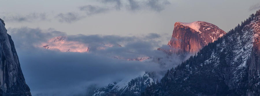
Rugged Half Dome,
March, 2016


Location Notes
Yosemite National Park is rich in history, spectacular vistas, and a multitude of powerful, gigantic waterfalls. It is home to arguably some of the most picturesque vistas in the world, including perhaps the most photographed view on the planet, Tunnel View. Yosemite is also one of the most visited national park in the country, attracting around four million tourists every year. Each one of these travelers owes gratitude to the person who made the greatest influence to conserve the land that is now Yosemite National Park, John Muir. Enthralled by the natural splendor of the region, Muir immersed himself in the study and enjoyment of nature while working odd jobs to make a living. Later Muir would realize the potential impact he could make in lobbying to protect the region, and succeeded in convincing many others of this important ambition. President Lincoln signed the first legislation to protect the region in 1864, the first legislation of its kind. Later, due to the efforts of Muir and others, Yosemite National Park was created in 1890 placing the entire valley and much of the surrounding land under federal protection. The bill that created Yosemite National Park was signed in 1906 by Theodore Roosevelt.
For many interesting writings about the park, and many other enjoyable literary works, visit the Sierra Club website which holds a collection of books by John Muir . Here is a brief sampling from his book, “The Yosemite”, under the title “An Unexpected Adventure”:
“A wild scene, but not a safe one, is made by the moon as it appears through the edge of the Yosemite Fall when one is behind it. Once, after enjoying the night-song of the waters and watching the formation of the colored bow as the moon came round the domes and sent her beams into the wild uproar, I ventured out on the narrow bench that extends back of the fall from Fern Ledge and began to admire the dim-veiled grandeur of the view. I could see the fine gauzy threads of the fall’s filmy border by having the light in front; and wishing to look at the moon through the meshes of some of the denser portions of the fall, I ventured to creep farther behind it while it was gently wind-swayed, without taking sufficient thought about the consequences of its swaying back to its natural position after the wind-pressure should be removed. The effect was enchanting: fine, savage music sounding above, beneath, around me; while the moon, apparently in the very midst of the rushing waters, seemed to be struggling to keep her place, on account of the ever-varying form and density of the water masses through which she was seen, now darkly veiled or eclipsed by a rush of thick-headed comets, now flashing out through openings between their tails. I was in fairyland between the dark wall and the wild throng of illumined waters, but suffered sudden disenchantment; for, like the witch-scene in Alloway Kirk, “in an instant all was dark.” Down came a dash of spent comets, thin and harmless-looking in the distance, but they felt desperately solid and stony when they struck my shoulders, like a mixture of choking spray and gravel and big hailstones. Instinctively dropping on my knees, I gripped an angle of the rock, curled up like a young fern frond with my face pressed against my breast, and in this attitude submitted as best I could to my thundering bath. The heavier masses seemed to strike like cobblestones, and there was a confused noise of many waters about my ears–hissing, gurgling, clashing sounds that were not heard as music. The situation was quickly realized. How fast one’s thoughts burn in such times of stress! I was weighing chances of escape. Would the column be swayed a few inches away from the wall, or would it come yet closer? The fall was in flood and not so lightly would its ponderous mass be swayed. My fate seemed to depend on a breath of the “idle wind.” It was moved gently forward, the pounding ceased, and I was once more visited by glimpses of the moon. But fearing I might be caught at a disadvantage in making too hasty a retreat, I moved only a few feet along the bench to where a block of ice lay. I wedged myself between the ice and the wall and lay face downwards, until the steadiness of the light gave encouragement to rise and get away. Somewhat nerve-shaken, drenched, and benumbed, I made out to build a fire, warmed myself, ran home, reached my cabin before daylight, got an hour or two of sleep, and awoke sound and comfortable, better, not worse for my hard midnight bath.”
Yosemite was originally occupied by the Ahwahneechee people some 3000 years ago. The first Euro-Americans discovered the region in the middle of the 19th century during the period of the gold rush. Conflict ensued and the native Americans were forced out of the area. Tourists began visiting the valley shortly thereafter.
The famous and influential black and white photographer Ansel Adams is well known for his iconic images of nature and has a deep rooted connection with Yosemite. Adams, who had a love of nature, visited the park as a child and later took images of the natural features of the park which began his renown as a photographer. In Yosemite Valley, the Ansel Adams Gallery features his work and that of other, more contemporary, photographers.
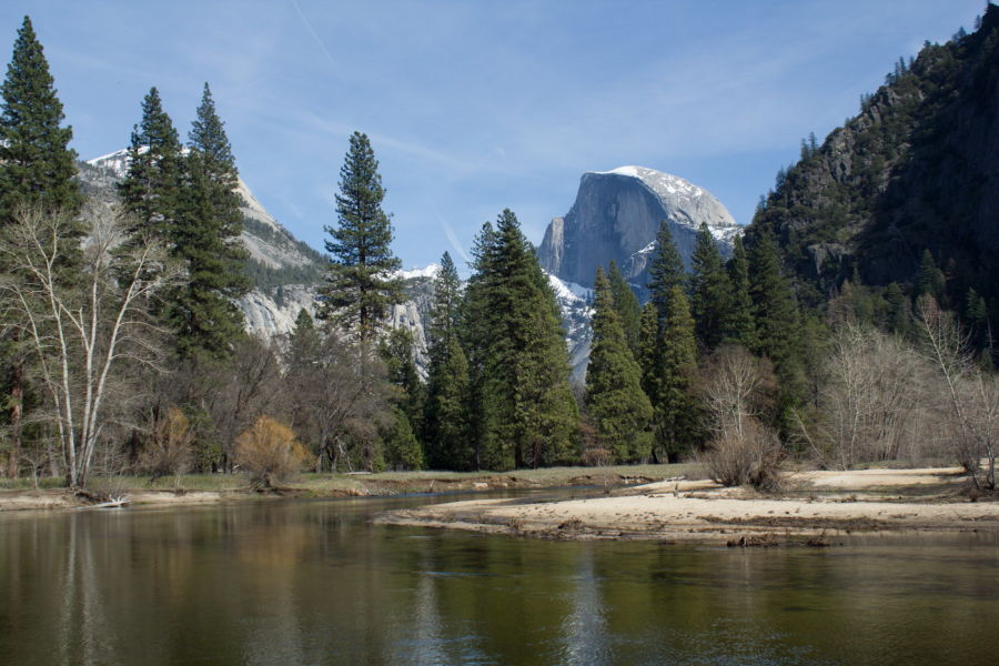
I visited the park in spring when the temperatures were temperate but snow still covered much of the high ground. We drove into the park when clouds obscured our views of the iconic scenery. However the next morning there was a break in the weather and Upper Yosemite Falls revealed itself to us for the first time. It was a staggering sight towering above the valley floor. One can walk to the top of the falls by taking the Upper Yosemite Falls trail which is a 7 mile round trip journey that provides views of the falls, as well as Half Dome and the valley below.

My favorite hike during our trip was the Mist trail which takes you to Vernal Falls. It continues on to Nevada Falls if you wish to have a longer trek. We took the John Muir trail on the way towards the falls, and the Mist trail on the way back. The Mist trail is so named because of the powerful spray that emerges from the base of Vernal Falls and soaks the path that leads to it from below. At the time we visited, the mist created a rainbow which only added to a view that was one of the most memorable I have ever experienced.

The vista from Tunnel View provides sights of some of the most iconic scenes in the valley, such as El Capitan, Cloud’s Rest, Half Dome, Sentinel Rock, Cathedral Rocks, and Bridalveil Falls. Seeing this view at sunset for the first time was an amazing experience. One fellow spectator exclaimed that it was perhaps the most beautiful sight he had ever seen. I imagine this opinion was shared by many of the visitors. I, however, was additionally trying to determine if it was the best view I had seen that day, comparing it to that of Vernal Falls from that afternoon. Appearing like paparazzi, there was a mass of photographers taking pictures at the overlook. Fortunately they all tended to stay in one location, so it was possible to find a little space farther down the overlook. I stayed there watching the sunset and then remained after dark to view the scene under moonlight. I also returned before dawn to observe the Milky Way arching above the valley across the sky overhead.

Observing the same natural wonders as those described in Muir’s writings endow them with a sense of timelessness. From Native Americans to you and I, generations after generations have come and observed the awe-inspiring natural features of the region. Some may say that if the grandeur of El Capitan, Yosemite Falls, or Half Dome were not enough to make you feel diminutive in comparison, the perspective of ones place in time assuredly will. Yet perhaps it is not the sense of smallness that pervades ones thoughts when in the midst of such grandness, but rather the awareness of the greatness reflected in that which is observed.


Saguaro
Saguaro

The Desert Saguaro,
December, 2014


Location Notes
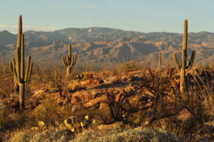
Saguaro National Park is located in the Sonoran desert region of Arizona. It is in very close proximity to Tucson which makes it easily accessible. It is named after the protected saguaro cactus. The saguaro can tower to heights of over 40 feet and can live for centuries. There are numerous species of cacti in the park, such as the prickly pear, teddy bear, jumping cholla, barrel, and many others. The jumping cholla gets its name from how easily its prickly appendages detach, seemingly jumping off the plant. The thorns of these plants easily come off and stick into your skin, so avoid touching or bumping into them. I saw a road runner outside our hotel during our short visit, and there were jack rabbits throughout the park. Saguaro National Park is not as well known as many of the larger parks, and although it may not be as impressive, it is very unique and overall it was a great park that is well worth visiting.
Acadia
Acadia

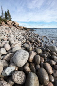
By the Blue Sea,
October, 2016
Location Notes
Located on Mount Desert Island on the Atlantic coast of Maine, Acadia National Park is one of the smallest national parks and is also the only one in the northern part of the East Coast of the United States. The park was formed by the donation of land by private owners who wanted to preserve the region and keep it free from development. Among the instrumental contributors to the park’s creation in the early 18th century were Charles Eliot, Charles W. Eliot, and George Dorr, all of whom enjoyed spending time in their island homes and had a vision for the land’s future. Later, John Rockefeller Jr. tripled its size from 5,000 to 15,000 acres and built the “carriage” roads through the park to make access to many scenic location in the park easier, which are still in use today. The Rockefeller’s have a continuing connection with Acadia; in fact, John Rockefeller Jr.’s son, David Rockefeller, celebrated his 100th birthday in 2015 by donating over 1000 additional acres to the park, which today contains 47,000 acres.
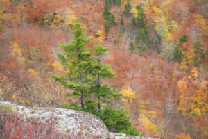
Just outside the park’s boundary is a small town called Bar Harbor which has many restaurants and shops, providing a nice place to go after spending the day in the park. We traveled to the park in late October just when the town began closing down for the winter and the crowds were decreasing. This was also a time when the leaves were just past peak color, although there were some patches that were just now in full display. Walking along one of the carriage roads provided a way to see the color up-close as well as presenting views of many attractive sights of the land. The carriage roads provide a great place to go for a stroll or bike ride as an alternative to a more strenuous hike.
One of the most striking displays of color came from the numerous huckleberry bushes that adorn much of the landscape, and whose leaves turned a deep red hue. Another prominent feature on the Acadia landscape is the rocky surfaces that cover many of the trails. The rock adds to the trails personality and is quite nice to walk on in my opinion, acting like a natural pavement. One trail was made entirely of beach-ball sized, rounded, rocks that were on a steep incline on a mountainside. The only delineation between the trail and the rest of the mountain was blue paint on some of the rocks. It led to a lake’s edge and a small, unusual looking footbridge. There were many outstanding hiking trails in the park, some of which traverse the mountainous geology, carve through the forested regions, skirt the boundaries of the scenic lakes, or follow the majestic coastline.
The mountains in the park are small enough to be ascended in a relatively short amount of time, but large enough to provide expansive views of the vistas. There is a road that provides access to the peak of Cadillac Mountain which gives views of many small islands off the Atlantic coast, the town of Bar Harbor, and many other landmarks and features of the landscape. For about half the year, it is also the first destination in the country to feel the morning sun’s rays.
We only spent a few days in the park, and it was completely cloudy nearly the entire time we were there, preventing me from capturing Acadia’s starry night sky, which I had heard is quite nice. In most cases the best lighting for photos happens near sunset or sunrise, but the clouds prohibited the sun’s light from producing any color for most of our trip. The only exception was the morning of our last full day when there was a partial break in the cloud cover. I took advantage of the opportunity by heading out around 6:45 am, 45 minutes before sunrise. It was already light outside as I drove toward the park loop road with the intent of finding a location along the coast to see the sun coming up over the horizon. As I drove along a road that was elevated on a mountainside, I saw a bright red luminescence on the horizon. At this point I wished I had set out even earlier, but I still was hoping for a nice display later on when I would arrive at the place I was heading. I parked near Thunder Hole, a location along the rocky shoreline that is known to produce thunderous sound at certain times of day the waves crash into a certain formation in the rock. I immediately setup my camera and began taking pictures, at this point about 10 minutes before sunrise. It was a beautiful sunrise, as most sunrises are (although I don’t generally see many of them), and I continued to shoot as the sun rose and was obscured by clouds. I then walked along a trail that follows the scenic coast and provides many regions where one can meander around on the rocks or down on one of the rocky beaches on which unusual looking, egg-shaped, rocks reside. The night before we were fortunate enough to spot a porcupine along one of the roads in the park. The only other animals we observed in the park were deer and red squirrels, although moose, bald eagles, and harbor seals do inhabit the area, and whales sometimes can be seen offshore.
Acadia is a beautiful and unique park that is consistent with what I have come to expect from the national parks I have visited so far. Each one I have experienced has been incredible and special in its own way. It is impossible to compare one to another since each has its own unique qualities. Acadia has wonderful hikes, spectacular views of the lakes, forests, and rocky coastline, and a wild, rawness, about it that I found very appealing. The only part of the park that one wishes would be different would be the size; it would be better if there was more of it, as unfortunately it is one of the smallest national parks and one can gets a sense of this when sounds from nearby towns are heard while walking in certain parts of the park, such as Gorham Mountian trail (which was one of my favorite hikes during our trip). I also enjoyed walking on the carriage road and imagine it would be wonderful to bike as well. Jordan Pond stands out as a particularly scenic spot also. It is fortunate that this land was aside for preservation and enjoyment for the public. Acadia holds its own as a unique national park, not just in terms of being alone geographically, but also with respect to of its natural composition.
Zion
Zion

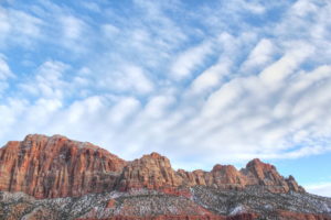
Red Rocks of Zion,
December, 2012

Zion Rock Face,
December, 2012


Location Notes
Zion National Park is one of the most iconic national parks in the country. What makes Zion unique is its towering red rocks, spectacular views, amazing slot canyons, and a collection of incredible hikes.

Some of the most popular hikes in the park include Angel’s Landing and The Narrows. Angel’s Landing takes one up a multitude of switchbacks before reaching the summit some 1,500 feet above the valley floor. From here one can climb the precarious trail that leads to Scout’s Lookout and gives an expansive view of the valley below. The Narrows is a unique hike that follows a river inside a gorge of Zion Canyon. Hiking through the river and looking up at the steep canyon walls makes for a memorable experience. Another wonderful trek, and perhaps my favorite in the park, is the Observation Point Trail. It is 8 miles round trip and ascends over 2000 feet from start to finish. It offers wonderful views of the enormous red canyons that form the vast scenery.
Olympic
Olympic

Sol Duc Falls,
July, 2018

Moss Forest,
July, 2018


Location Notes
The Pacific Northwest is home to picturesque coastline, temperate rain forests, old growth forests, spectacular mountain ranges, and other natural wonders that truly make it a unique and wonderful location. There is little wonder why there are several national parks in this region. I visited two of them, Mount Rainier and Olympic, during an 8 day trip that I took in 2018, my first visit to this area of the country. Both of these parks offer wonderful views and experiences that come from having a location set aside to nature, and the Pacific Northwest provides for a fantastic region to visit due to its unique setting.

Located on the Olympic Peninsula, a few hour drive to the northwest of Seattle, Olympic National Park contains a remarkable diversity of eco-systems. From the coastline, to the Olympic Mountains, to the temperate rain forests, the variety of scenics makes it one of the most unique parks in the country. An immense amount of bio-mass fills the temperate rain forests, which receive around 150 inches of rain per year. Unlike a tropical rainforest, the forests here contain conifers and have the appearance of being similar to other forests in the state except for the exceptional lushness and proliferation of plant life on every piece of land. Long, dense, mosses hang from the trees, giving the perception that the forest is literary dripping with life. Unlike most of the year, the summer provides a brief window of typically clear, precipitation free, days. Although the rainforest is the most renowned aspect of the park, we found the coastline and mountainous region to be our favorite parts of the park. Spectacular views of wildflowers and the Olympic Mountains accompany the trails at hurricane ridge, while on the coast one can walk along the beach and explore the seaside intrigues as well as take in the views of the rock outcrops jutting out of the water just off-shore.
Mount Rainier
Mount Rainier

Leaf Textures,
July, 2018
Location Notes
The Pacific Northwest is home to picturesque coastline, temperate rain forests, old growth forests, spectacular mountain ranges, and other natural wonders that truly make it a unique and wonderful location. There is little wonder why there are several national parks in this region. I visited two of them, Mount Rainier and Olympic, during an 8 day trip that I took in 2018, my first visit to this area of the country. Both of these parks offer wonderful views and experiences that come from having a location set aside to nature, and the Pacific Northwest provides for a fantastic region to visit due to its unique setting.

Located within just a couple hour drive of Seattle, Washington, Mount Rainier National Park contains beautiful views of the massive mountain for which the park is named, as well as scenic trails through the majestic forests made up of cedar, fir, and hemlock, some of which are over 1000 years old and tower 200 or more feet toward the sky. During the summer months, wildflowers proliferate and mild temperatures surround the bottom of the mountain. Even so, snow still covers areas of the park this time of year due to the immense amount of it that falls every winter. In fact, the Paradise region of the park is one of the snowiest places on Earth, where snowfall is regularly recorded. The region once measured a world record annual snowfall of over 1000 inches. The deepest snow depth measured on the ground here was a staggering 30 feet. The mountain itself is the largest of the Cascade Range, with a height of over 14,000 feet, and supports 26 glaciers on its slopes. John Muir had this to say about the mountain: “Of all the fire-mountains which, like beacons, once blazed along the Pacific Coast, Mount Rainier is the noblest”. The mountain is an active volcano and is considered to be one of the most dangerous in the country because of its potential to affect closely located populous areas.
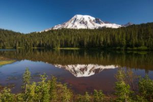
The mountain is quite impressive in appearance, and is visible from cities up to a couple hundred miles away on clear days. The Paradise region of the park offers the closest views, but I found there to be many fantastic vistas in other areas where the mountain is not the foremost object of attention. The undulating landscapes display beautiful forests, rivers, lakes, and waterfalls that make the entire park worthy of admiration.

More Locations
More Locations


Location Notes
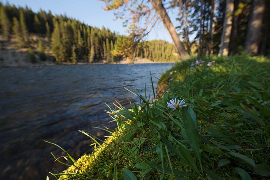
I traveled to Yellowstone National Park in August, 2017, in order to combine a visit to an amazing national park with the observation of the total solar eclipse. Although not my first trip to the park, I saw it with a different perspective on this occasion. Previously I had been more of a spectator, whereas this time I explored some of the hiking opportunities in the park while also keeping an eye out for good photographic opportunities. Two of my favorite trails were Wapiti Lake and South Rim. The Wapiti Lake trail takes one through open plains with expansive views on all sides. The trail splits at one point and gives the option of either going toward Yellowstone Falls or farther into the open plains. I took the section heading towards the falls and saw many wildflowers on the sides of the path which made for quite beautiful scenery.
The South Canyon Rim trail provides a wonderful view of the impressive Lower Yellowstone Falls, which has a drop of over 300 feet. I also enjoyed walking to the lookout point at the top of Upper Yellowstone Falls which, although is only about a third of the height of the Lower Falls, presented an incredible spectacle of power and beauty.

Going in the middle of summer, and around a hugely popular event, presented some challenges. The crowds meant that getting to some spots were not possible during the busier times of the day, however these sites were generally much easier to access in the mornings. Because of the long days and short nights, there are not many opportunities for sunrise, sunset, or nighttime photography (at least if one wants to maximize the daytime hours for hiking or sightseeing). However, Yellowstone offers wonderful photographic scenes even during the harsher lighting of the daylight hours. Its unique landscapes contain mind-blowing sights of geysers, colorful hot springs, and wildlife, sometimes all in one location. The animals in the park have found ways to live with the unique conditions that arise from the volcanic activity. Some of them even take advantage of the thermal heat to stave off the biting cold of the harsh winter conditions. The parks valleys sit at an elevation of around 8,000 feet, making for extremely cold and long winters. In summer, the temperatures are warm during the day and cool at night, making it the most popular time for most visitors to see the park.

Yellowstone was the first place to be designated a national park, which occurred in 1872. Although the first land to be set aside specifically for preservation by an act of the U.S. government was Yosemite, in 1864, the national park designation gave Yellowstone federal, rather than just state, protection.
The supervolcano that sits beneath the Yellowstone surface has produced some of the largest eruptions of any volcano in the world. The term “supervolcano” refers to the unusually great size of the volcanic eruptions that have occurred in the past. It has erupted three times in approximately the last two million years, at an average of about 750,000 years in between each event. Fortunately, the chances of another eruption occurring anytime in the near future is extremely low. If such an event did occur, it’s hard to imagine the amount of destruction that would be done to such a spectacular place and to the wildlife that inhabits the region. However, the past eruptions clearly did not prevent the existence of the wonderful characteristics that we see there today; in fact, perhaps many of their aspects are due to it.


Location Notes
As the name implies, Rocky Mountain national park resides in the Rocky Mountains where there are grand mountain peaks, meadows in the lowlands, evergreen forests, rivers, waterfalls, and wildlife such as moose and elk. The elevation within the park varies from approximately 8000 to 14000 feet, producing a wide variety of ecosystems. One can experience beautiful views while walking in the valleys of grassy meadows or conifer forests, or expansive vistas at higher elevations on the alpine tundra zone where the conditions are too harsh for trees, creating an unusual landscape of wide open terrain. In the subalpine zone, trees are smaller in size and often more gnarled in appearance than the same species at lower elevations. About one third of the park sits above the tree line where resilient grasses and other small plants etch out a living. In June and July, wildflowers can be seen in the meadows, and in Fall the aspen trees provide autumn colors to the landscape.

The east side of the park is located about an hour and half drive from Denver, making it easily accessible and therefore also highly visited. The majority of the most popular hikes are on the east side, where there are beautiful lakes, waterfalls, and mountain peaks. Although less visited, the west side of the park has many spectacular hikes as well, and also is in close proximity to national forest land where there are additional hiking possibilities. In summer, one can drive along the scenic trail ridge road which connects the east and west sides of the park. It is a long trip from grand lake in the west to the Estes region on the east however; taking about 2 hours. If trail ridge road is closed, it’s also possible to go around along the outside of the park, which is about a 3 hour drive.
On my first visit to the region, I stayed in Winterpark, a ski town near the western area of the park which provides convenient access to the park and the national forests. Popular trails near the west entrance include coyote valley and green mountain, as well as a trail that begins at the valley floor and ascends to a mountain peak, the Ute trail. This hike was particularly memorable for its spectacular mountain views and the challenges presented by the high elevations. The hike begins at 10800 feet and ascends to 12000 feet, passing from a scenic lake, through subalpine forest, and finally reaching alpine tundra at the last stretch up to the alpine visitor center. There are views of neighboring mountains most of the way up, and spectacular vistas of snowy mountain peaks along the final stretch of the trail. Once at the high elevation, my hiking group and I experienced the affects of the low oxygen levels, such as dizziness and nausea, which is quite common for those not accustomed to the high altitudes. A ranger informed us that it takes about one week to fully adjust to every 1000 feet of elevation gain. When feeling altitude symptoms, it is recommended to drink water and, if the symptoms are severe enough, head toward lower elevations. Another hazard one needs to be aware of when hiking in the mountains is lighting. Thunderstorms often roll in during the afternoon and present danger to those exposed at the higher elevations. It is suggested that you begin your hike early so that you can finish before the afternoon. Conditions can change rapidly and predictions are uncertain. We were hiking in the tundra zone when a storm seemed to be threatening, however fortunately it never developed into more than just wind and dark clouds.
Another hike that I recommend on the west side of the park, in the Grand Lake area, is the East Inlet trail. The first section of the trail is fairly flat and, being at low elevation, makes for a good option while still acclimatizing. There are spectacular lookouts in this area that display a valley with a river and grassy meadows, and impressive mountains beyond. The hike continues for a much longer distance to mountain lakes if one desires a more challenging undertaking.

There are many opportunities to observe wildlife in the park; I observed moose, many elk, and marmots. In addition there are cougars, coyotes, black bears, and bighorn sheep within the park. The region is also home to a diverse array of other wildlife due to its variety of ecosystems. Wolves, bison, and grizzly bears once inhabited the area but unfortunately were extirpated about a hundred years ago.
Rocky Mountain National Park is another unique gem in the collection of our nation’s national parks that allows one to experience the grand mountain vistas and quiet rivers, meadows, and forests in this piece of beautiful land.

Location Notes
Thought to most likely be named after the mist that rises from the earth in the mornings, creating a smoky appearance, the Great Smoky mountains contain several of the highest peaks of the Appalachian mountain range. Great Smoky Mountain National Park, residing primarily in Tennessee and partly in North Carolina, encompasses a large portion of these mountains. It is one of the relatively few national parks in the eastern part of the country, as well as one of the largest. Featuring a rugged landscape with forests, rivers, mountains, wildlife, and beautiful flora, while also being in relatively near proximity to the populated eastern coast, it is little wonder that the Great Smoky National Park is the most visited national park in the country.

The great smoky mountains were inhabited by native peoples for thousands of years prior to the arrival of European-American settlers in the 1700s. The native people were forced to leave the region in the 1800s.
Although the early settlers lived a rustic lifestyle, a logging boom changed the economic and social environment in the early 1900s. Due to the environmental impact of the logging, concerned citizens raised money to conserve the land and, with the assistance of government and private donors, the land was purchased for the establishment of the national park, which came in 1934. Approximately 20% of the old-growth forests still remained. Residents of the area left willingly, were evicted, or in some special circumstances were allowed to remain, albeit while living under certain restrictions.
Visitors to the park may see wild turkeys, black bears, coyotes, elk, or other wildlife. Other attractions include the synchronous firefly displays and wildflowers on the springtime, as well as the beautiful fall color in autumn.
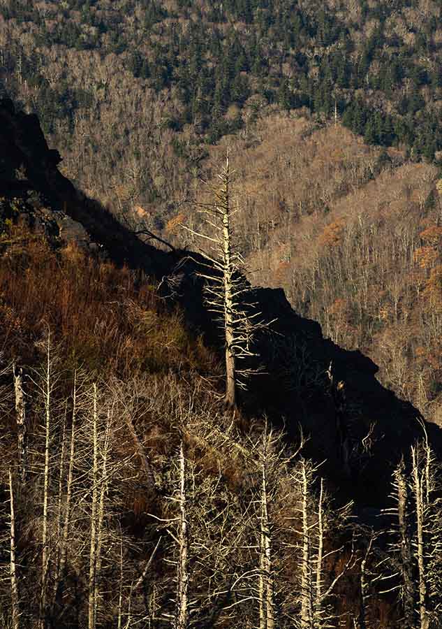
I traveled to the park at the end of October, hoping to see the fall foliage color change. Because of the large elevation disparity in the park, from approximately 900 to over 6,600 feet, the changing color of fall moves down from higher to lower regions of the park over a course of several weeks. Therefore, typically the peak color occurs at the start of October at the higher elevations and at the end of the month at lower elevations. The year I visited, the color change came early the year, and only small pockets of color were still visible. However, the landscape did not require the additional color to be quite impressive in appearance, displaying churning rivers flowing through rocky riverbeds lined by mountain laurels, rugged mountain terrain, vistas of rolling mountains and valleys, and cascading waterfalls. Uncertain about the scale of the mountains prior to my arrival, I was pleasantly impressed by their appearance, more closely resembling the steep peaks out west rather than the more rounded mountains of the northern Appalachians. I experienced the effect of this steep terrain during the hike up the Chimney Tops trail, which is just over 2 miles from the start to the top, but rises about 1000 feet in the second mile, and about 1,400 feet overall. As of the time of writing this in early 2021, the section around the chimney top rock formations is closed due to a devastating wildfire that occurred in 2016. There is an observation point that looks towards the rock pinnacles and Mount LeConte, however.
I also enjoyed hiking to Alum cave, which is a 80 foot high and 500 foot long overhanging rock on the mountainside. Drops of water dripped down from the edge of the rock above, falling like rain. The trail itself is quite nice, as it crosses streams over logs and through a natural tunnel at Arch Rock.

Another hike, Andrews Bald, took me from one of the highest points east of the Mississippi before passing through a beautiful and dense spruce-fir forest carpeted in mosses, then ending at a grassy meadow with views of the surrounding mountains and valleys. Note that if you go to this hike, or to any in the Great Smoky National Park for that matter, it is best to arrive early, perhaps before 10 am or so, to find a parking spot. I stayed in Gatlinburg, Tennessee, which is relatively close to the park entrance on the north side. From central Maryland, it was about an 8-and-a-half-hour drive. One can also go part of the way on all or part of the Blue Ridge Parkway, which is known to contain spectacular views of the autumn foliage on the mountains, particularly, I have heard, in the southern regions. However, this will add to the total trip duration due to the much slower driving speed compared to the highway.